|
Aerial Photographs - Tottenham English Heritage - Britain from Above |
|
|
Aerial Photographs - Tottenham English Heritage - Britain from Above |
| The
first commercial aerial photography company in the UK was Aerofilms Ltd, founded by World
War I veterans Francis Wills and Claude Graham White. Wills had served as an Observer with
the Royal Naval Air Service during the Great War, and was the driving force behind the
expansion of the company from an office and a bathroom (for developing films) in Hendon to
a business with major contracts in Africa and Asia as well as in the UK. Co-founder
Graham-White was a pioneer aviator who had achieved fame by making the first night flight
in 1910. The entire Aerofilms oblique collection, comprising some 1.26 million negatives
and 2000 print albums, is now held in the English Heritage Archive in Swindon, UK. Many of these old aerial photographs have now been digitised by English Heritage and are available to view from their website. Thankfully you are permitted to download these images provided you acknowledge the source and provide the reference number. We have therefore collected just a few of the many images showing Tottenham which we are showing below. Hopefully you will be able to identify many of the places and locations pictured.
|
|
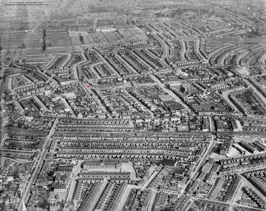
| IMAGE EPW056661 : This wonderful image was taken in 1938
and in the centre it shows Summerhill Road Tottenham. We have taken the liberty of placing
a small RED
mark at the junction of Summerhill Road with Clyde Road, to help you to orientate yourself
with the picture and its surroundings. In the extreme bottom left corner you can
just see the spire of St Ann's Church at the foot of Avenue Road and what we believe to be
South Grove School near Cissbury Road a little to the centre Towards the top left you can see Lordship Recreation Ground and to the right the fields and allotments that were the original Broadwater Farm. |
 |
| IMAGE EPW042080: This is yet another wonderful photograph showing the Harris Lebus factory in Ferry Lane Tottenham, taken in 1933. In the bottom right corner you can see the original forecourt to Tottenham Station (Now Tottenham Hale). For more information on the history of the 'Harris Lebus' company visit www.harrislebus.com |
|
| IMAGE EPW009245: One of many photographs showing the Tottenham Hotspur Football Ground in 1923. In the foreground you can see the front entrance on Tottenham High Road in exactly the same position as it is to this day. The current East stand was not constructed until 1935. |
|
| IMAGE EPW056647 Tottenham High Road in 1938. To the front left you can find Tottenham Bus garage with 'The Swan' public house situated on the corner of Philip Lane with the High Road. You can also see Tottenham High Cross just beyond High Cross Road as the High Road flows north towards Bruce Grove |
|
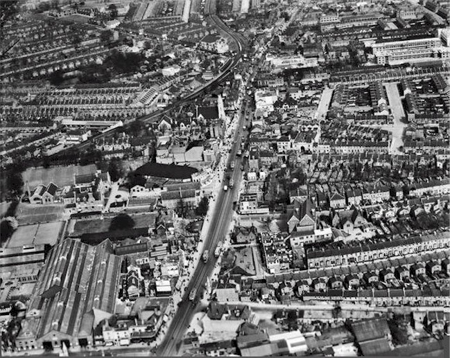
| IMAGE EPW056657 - Another view of Tottenham High Road in 1938 but this time from just north of West Green Road and Broad Lane. You can clearly see Tottenham Green and to the left the Town Hall and Civic buildings. On the eastern side of Tottenham Green you can see the former Prince of Wales Hospital. |
|
IMAGE EPW009962 - This is a view of Broad Lane towards Tottenham Hale with Fountayne Road to the right taken in 1924. At the bottom left is Page Green school. You can also see in Fountayne Road the Crown Works of John Dickinson's. You will note that much of the later Gestetner's premises have yet to be built and, as Ferry Lane sweeps over the railway lines, you can see the cabinet works of Harris Lebus on the right. |
 |
| IMAGE EPW009969 - This is a wonderful view of Tottenham Hale in 1924. As the road sweeps into the Hale at bottom left you can see 'The White Hart' public house and just beyond the 'Hope & Anchor' public house. The factory on the corner of what was Fawley Road would have been the shoe manufactures 'Flataue's'. |
|
| IMAGE EPW042009 - This is yet another wonderful view of Tottenham Hale taken in 1933. You can see Welbourne Road in the bottom left corner and High Cross Road towards the bottom right both running into Tottenham Hale.. The road opposite was Hale Road and you can see the factory of Lorilleux & Bolton (printing ink manufacturers) and what appears to be The Eagle Pencil Company in the background. On the right side you can once again see the 'White Hart' public house on the corner of Station Road and the entrance to Tottenham station in the distance. |
|
IMAGE EPW042081 - This is a view which I believe would have been taken from close to Markfield Park in 1924. In the distance you can clearly see the factory chimney of 'Harris Lebus' and beyond Ferry Lane as it sweeps from left to right across the River Lea at Tottenham Lock towards Walthamstow. |
|
||
| IMAGE EPW047015 - In the bottom right corner you can see both Bruce Castle Museum and Bruce Castle park taken in 1935. To the left side you can see the allotments at the former Broadwater Farm and Lordship Recreation Ground beyond. However it is the layout of the Tower Gardens estate and The Roundway sweeping round from the Great Cambridge Road in the distance to Risley Avenue that runs just behind Bruce Castle park. | ||
|
||
| IMAGE EPW047014 - Another photograph dating from 1935. In the bottom left corner you can see All Hallows Church and the grounds of Tottenham Cemetery. Just to the right you will find the playground of Risley Avenue School. The Tower Gardens estate then unfolds before you towards Lordship Recreation Ground. In the far distance, just right of centre, you can see Belmont Recreation Ground (Often referred to as the Little Rec) located at the western end of Downhills Park Road. | ||
|
||
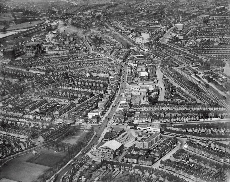
| We are uncertain whether this photographs originates from the English Heritage collection but it is one we have on file and captures Wood Green High Road and its junction with Lordship Lane and Station Road. We believe this image dates from the 1930's and was obviously prior to the construction of the Odeon Cinema and shops along the western side of the High Road. The old Noel Park Station on the Palace Gates railway line is just out of picture on the bottom left corner. |
|
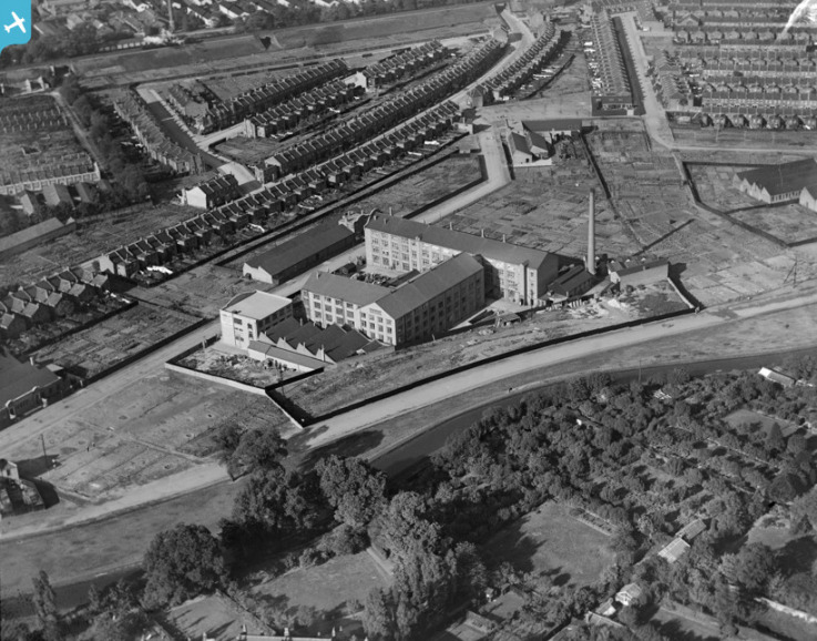
| IMAGE EPW007024 This is just one of many photographs in the English Heritage collection showing Maynards Confectionery works in Vale Road Harringay in 1921. The picture is pointing North-East from the Finsbury Park area. The picture shows a largely undeveloped Vale Road leading towards Hermitage Road. In the top right corner you can see Tiverton Toad and branching to the right both Overbury Road and Netherton Road leading to Tewkesbury Road and eventually the Seven Sisters Road. |
|
| IMAGE EPW008756 This photograph shows the
former Harringay Stadium and Harringay Arena taken in 1947. Harringay Stadium was one of
the top sporting venues in London and regularly held Greyhound Racing, Speedway and
Athletics events. The nearby Arena held World title Boxing matches, the Horse of the Year
show as well as Ice Skating and top Circus events. It also famously held the first London
Crusade by the American evangelist Billy Graham in March 1954. It is estimated that over a
twelve week period over 1.7 million people attended the events. Just beyond the
arena is Green Lanes Harringay as it sweeps to the right and northwards towards Turnpike
Lane. At the very foot of the photograph on Hermitage Road you can just make out the factory of Challen's one of the most famous Piano manufacturers in the world. |
|
| This later photograph is not one from the English Heritage collection but it does help show many of the locations around the former Harringay Stadium complex. |
|
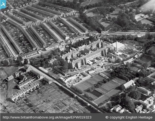
| AGE EPW019323 This photograph dating from 1927 shows the Strand Union Workhouse that once operated in Silver Street Edmonton. This site now occupies the North Middlesex Hospital. In the top right corner you can see Pymmes Park and the road leading south is Bull Lane running towards Queen Street Tottenham. |
|
| And finally an old advertisement for Aircraft Cameras that we discovered during our research. This is quite apt considering that their address was Green Lanes Harringay. |


Article prepared by Alan Swain - November 2013