| Thank you for inviting me to report my memories of Tottenham on your website.. I will record snippets of information as they come to mind. Although it will not be story book reading it may contain bits that you can use in your overall jigsaw.I will try to collate them under various headings but there may be some overlaps. | |
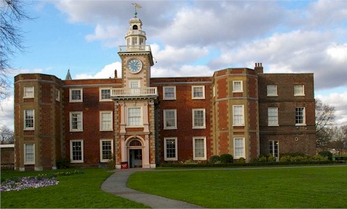
Bruce Castle Museum |
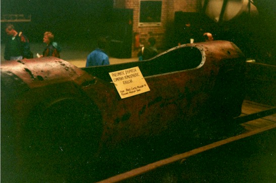
Tom Street's photograph of the Postal Cart now exhibited at the National Railway Museum. |
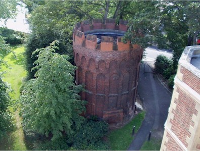
| In the front
garden and to the western side of the museum is a round tower which pre-dates the main
building (we were given to understand that Robert the Bruce once hid there!) but is now
used for groundsmans’ implements. In the 30’s the eastern side of the main building ground floor was used as a children’s clinic. During the war an old
detached house, opposite the north end of the park in Church Lane, was set on fire to
provide a practice/demonstration for the various A.R.P. services. I believe this was part
of a number of demonstrations promoting local services to the public, the main events
being held in the recreation ground. Like most properties, both public and private, it
lost its railings for munitions. |
|
|
|
Bruce Castle Museum - Tottenham |
The Round Tower- Bruce Castle Museum |
|
Lordship Recreation Ground I can confirm, as you have stated, that the tragic shelter was situated parallel to the fence to the right of the Downhills Park Road entrance. From this entrance the path ran down to the Moselle Brook passing the children’s traffic area, and provided us with a perfect run for our soap box trolleys. During the 30’s the construction of the traffic area gave us a wonderful play area with its small gauge railway and trucks for the transport of material (no JCB’s). |
|
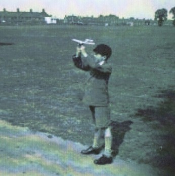
The area of the Rec, north of the Moselle, is very flat and of a good size: in suitable conditions it would attract model aircraft enthusiasts to test their efforts, much to the joy of us open mouthed kids. I have included a photo of myself (not recent) with a five shilling ‘Frog’ aeroplane. Lordship Lane is in the background.To the north-east corner of the Rec, next to the allotments, a barrage balloon was stationed. The old “Broadwater Farm House” was on Lordship Lane and backed onto the allotments. It was painted cream and had a pillar each side of the drive entrance and each was surmounted with a large red painted ball. |
A Young Tom Street Circa 1935 Lordship Recreation Ground |
|
Early Photograph of Broadwater Farm in Lordship Lane |
|
Downhills Park This park was always maintained to the highest standard and I can never remember it being vandalised. From the “Philip Lane” entrance, the path runs through a narrow section with oblong flower beds, each containing tulips of uniform colour and size in its individual variety. Halfway along this path was a circular ornate balustrade containing a goldfish pond. |
|
 |
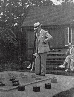
Mr A Lockyer - Draughts Downhills Park |
| The path continued to a large shrubbery area flanked, on the
right, by the bowling greens and a large outdoor draughts board (see photo) . The person
playing draughts was my uncle, A Lockyer, who lived at 7 Dongola Road, and he worked for a
London newspaper. He was also a founder of the print union N.A.T.S.O.P.A His hobby was to
buy up rented property in the area and he had over 200 through his hands during his
lifetime. In the area adjacent to Keston Road was situated a greenhouse which was a working, rather than a show, building and contained superb examples of chrysanthemums. I can only assume these were produced for corporate purposes. We, as kids, were allowed in, if we behaved. On the side of the park, opposite the water tower, was an open fronted wooden shelter that we would use at time of rain, but hated every minute as it stank of stale tobacco.
Napier Road |
|


 Palace
Cinema - Tottenham High Road
Palace
Cinema - Tottenham High Road